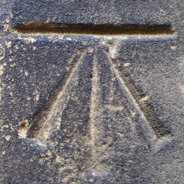
St Mary's Church
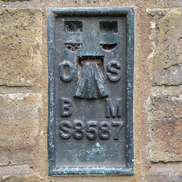
Registry Office
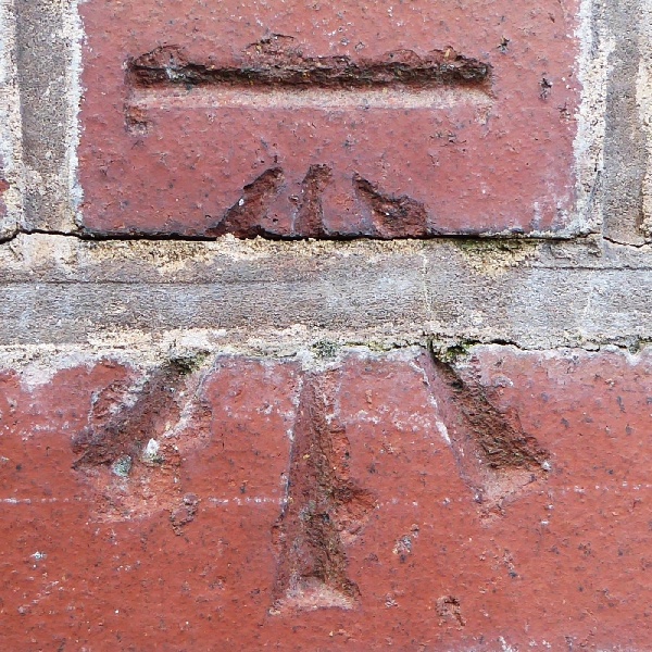
38 Dam Street
| Levelling up Lichfield | |
|
When visiting a historic town or city one is often advised to look upwards, above modern shop-fronts and fascias, to discover the age and history of a building. But sometimes it can also pay to look down, to just a foot or two above the pavement. Many of you will recognise the line and arrow symbol which designates an Ordnance Survey benchmark, although there are also several other types. How they came to be there is a long, complex, and extremely technical story. Suffice it to say that the Ordnance Survey manually and laboriously measured heights across Great Britain (the so-called "geodetic levelling") three times: firstly between 1840 and 1860 using the mean sea level calculated in a dock at Liverpool; then in 1912-21 and again in 1951-56; now based on the mean sea level at Newlyn Harbour in Cornwall. Heights in Lichfield were first measured along Trent Valley Road and Birmingham Road, a small section of a line of levelling along the main road from Sheffield to Birmingham. The second levelling saw about 200 "fundamental benchmarks" established across Great Britain. These are elaborate, with metal rods down into solid bedrock, concealed under a secure cover. The nearest to Lichfield are at Sandon near Stafford, at Melbourne in Derbyshire and at Nuneaton. The heights of all other benchmarks were then recalculated from these. It is what are known as cut benchmarks that most people think of when the word is used. An example is on the outside wall of St. Mary's Church, in Breadmarket Street, just round the corner from the Market Place, between the display window and the west doors (see photo below). Its height above mean sea level, measured along the centre of the horizontal line above the arrow, is 268ft 10in. (81.94m). At one time there were as many as 50 benchmarks within two miles of Lichfield's Market Place. A survey by some enthusiasts about ten years ago found that about half that number were still visible. Some date from the early 1880s and were derived from the first levelling. Others are more recent as additional marks were still being created as late as 1986 on the then new Boley Park estate. Almost all are cut benchmarks; but there is a fine example of a much less common type on the south wall of the Registry Office in the Museum Gardens, just behind Peter Walker's statue of Erasmus Darwin. This is a "flush bracket benchmark", made of metal and set into the wall (see photo below). On this flush bracket, "S8587" is a serial number and has nothing to do with the actual height, which is 269ft 1in. (82.02m) above mean sea level at Newlyn, measured at the top of the arrow. This is the only example of a flush bracket benchmark in Lichfield - the nearest others are at Seedy Mill (the Water Works), Hill Ridware and Croxall. With the development since the 1990s of advanced satellite imaging and global positioning systems, levelling and the measuring of heights are no longer done in the old-fashioned way. Few benchmarks have any statutory protection; most have been left to their own fate and they are now slowly disappearing because of building restoration or redevelopment, or simply through decay. For example, there was one on the parapet of the railway bridge over the West Coast Main Line on Burton Old Road near Trent Valley Station; but it was lost when the bridge was rebuilt not long ago. The cut benchmark near the corner of Beacon Street and Shaw Lane is starting to deteriorate. The surface of some of the bricks is spalling so, while the line remains clear, much of the arrow is eroding. While it lasts, its height is 292ft 11in. (89.29m). A benchmark in Bore Street is also beginning to disappear under thick layers of paint. How many more coats will it take before it finally fades from view? One on the boundary wall in front of 38 Dam Street has been disturbed. The sides of the arrow no longer form straight lines (see photo below). Evidently the wall has been taken down, an extra layer of mortar put in between at least three courses of brickwork and the wall then rebuilt. Even if put back in the same position, this means that the height of the horizontal line which was 268ft 2in. (81.73m) is no longer correct. It appears to have been raised by about two inches. Nowadays the locations and heights of benchmarks are only depicted on the largest-scale Ordnance Survey plans; those at 1:1,250 and 1:2,500. There is a list of over half a million benchmarks in Great Britain on the Ordnance Survey website, although even this is far from complete - for example the Bore Street mark is not included. But if you simply want to find out more about benchmarks in Lichfield there is a useful search facility on the website: www.bench-marks.org.uk You might think twice before adopting benchmark spotting as your new post-lockdown hobby; but why not keep your eyes peeled as you walk around the city and, in addition to those shown below, see how many you can find? The south transept of the Cathedral, the façade of Wade Street Church and the front of "Luminare" in Tamworth Street would be good places to start. They and the others won't be there for ever, so catch them while you can. William Henwood |
|
|
St Mary's Church |
Registry Office |
38 Dam Street |
| All photographs by the author | ||