When travelling at 70mph the miles pass quickly; one every 51.4 seconds to be exact. Surviving roadside milestones and mileposts are seldom noticed. On major routes it would be foolish to slow down to try to read them and usually impossible to stop and inspect them; but a long sequence of such markers can still be reassuring. The writer recalls the days of his youth, driving the long and lonely road across the Dorset and Wiltshire Downs, sometimes in bleak mid-winter, in an old and unreliable car, counting down, mile-by-mile, progress towards home and civilisation.
The golden age of milestones and mileposts is usually thought of as being the turnpike era, roughly 1750-1850, but their story stretches much further back (the Romans used them) and forward to the present day.
Early mile markers were made of stone, with destinations and distances inscribed into them; hence, milestones. Later, this information was contained on one or more cast iron panels attached to the stone. Later still, cast iron was used for the whole structure; these are usually referred to as mileposts.
When County Councils were established in 1889 they were made responsible for highways. Many councils then added or replaced mile markers along their major routes.
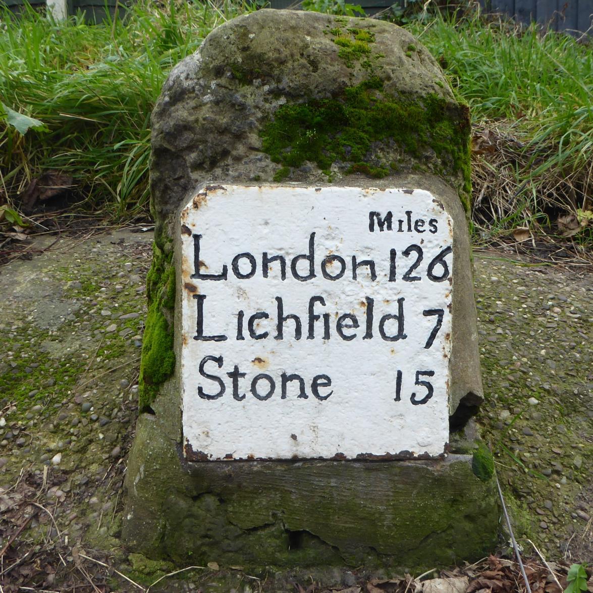
In 1893 Staffordshire County Council paid for 335 cast iron mileposts from Charles Lathe and Co. of Tipton. Further batches were bought from Cochrane and Co. of Woodside, Dudley, in 1909 and 1910. It is these replacements, rather than the earlier turnpike-era milestones, that are most often seen along the county's roads today.
Travel by road in the 1890s was slow, on foot or horseback, by coach or cart, or increasingly by bicycle; so each mile's progress was worth knowing. Lying in the centre of England, where several major cross-country routes converge, one might expect Lichfield to have been a focal point for distance markers and one would not be disappointed.
So, how many of these reminders of a bygone era of travel can still be found in and around Lichfield today and what additional information can old Ordnance Survey maps provide? Let us take a clockwise tour of the six main roads in and out of the city, beginning with Trent Valley Road.
This well-maintained milepost was made by Cochrane & Co., so dates from about 1910. It stands on the south side of Trent Valley Road, by the pedestrian crossing just east of Trent Valley Island. It is shown on the 1921 Ordnance Survey map; but that map also marks "Old M.S." beside Trent Valley Road a little nearer to the city centre. That milestone is no longer to be seen but will almost certainly have belonged to the turnpike era. Since Trent Valley Road was built in the 1830s, to replace the earlier turnpike route which ran along Burton Old Road, there may well have been a milestone there; somewhere near the level crossing. Perhaps it was moved to the new Trent Valley Road.
|
Local Mileposts
«« The milepost on Trent Valley Road The milepost on Tamworth Road »» |
|
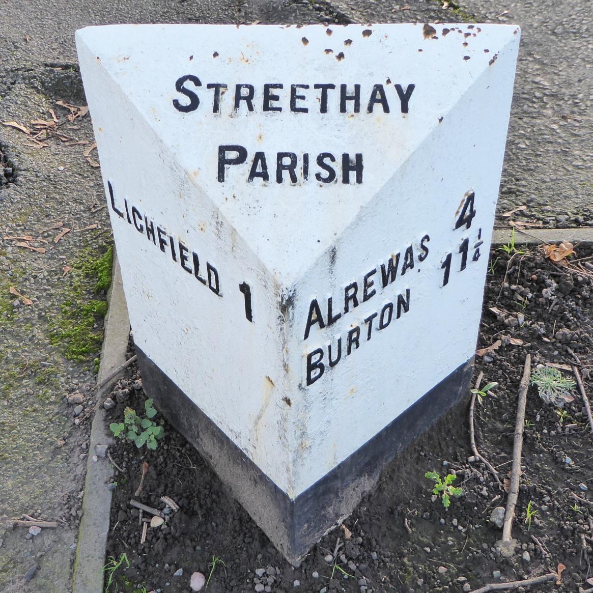
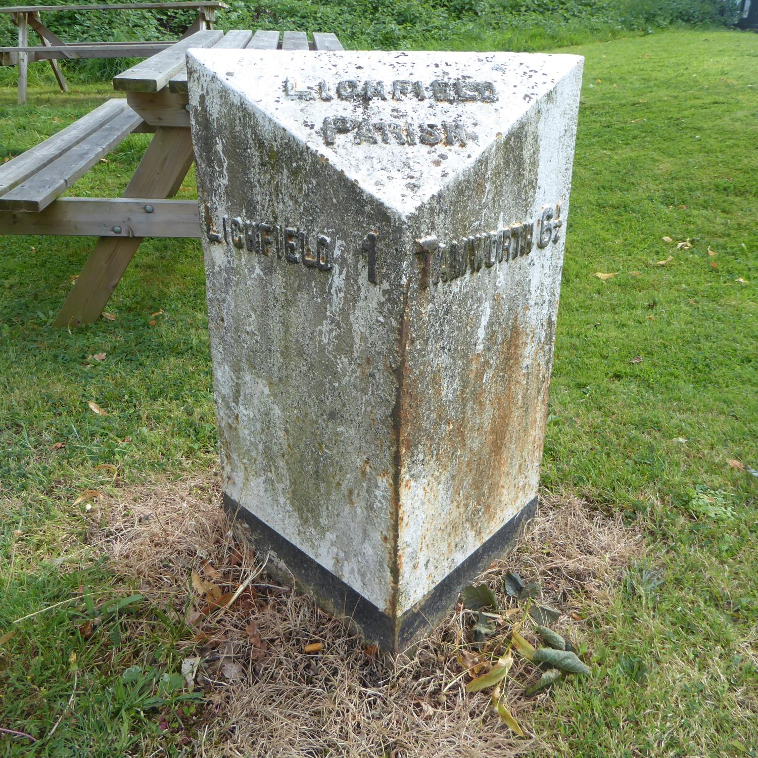
Our next port of call is Tamworth Road. Here another Cochrane & Co. milepost, similar to that in Trent Valley Road but in need of a little TLC, stands on the south side about halfway between London Road and Cricket Lane. This tells us that it is in Lichfield Parish, 1 mile from Lichfield and 6¼ miles from Tamworth.
It is shown on the 1921 OS map but, as in Trent Valley Road, "Old M.S." is also marked, several hundred yards further to the east though not to be found today. An earlier OS map tells us that it read "Lichfield 1 | Tamworth 6".
The differing locations of old milestones and later mileposts which carry the same information prompts questions: from where were the distances measured; and how accurately? It is reasonable to assume that the Market Place in Lichfield will have been the point of origin but, as will be seen later, mile markers did not always stay put. Distances were often only approximate, though there are examples of great precision: a milepost on the outskirts of Tenby in Pembrokeshire confidently states that the town of Narberth is 10 miles and 970 yards away!
The OS map covering Tamworth Road also shows both a milepost, "Lichfield 1 | Coleshill 14" and an older milestone on the west side of London Road, not far south of Gallows Wharf. Unfortunately, neither survives today.
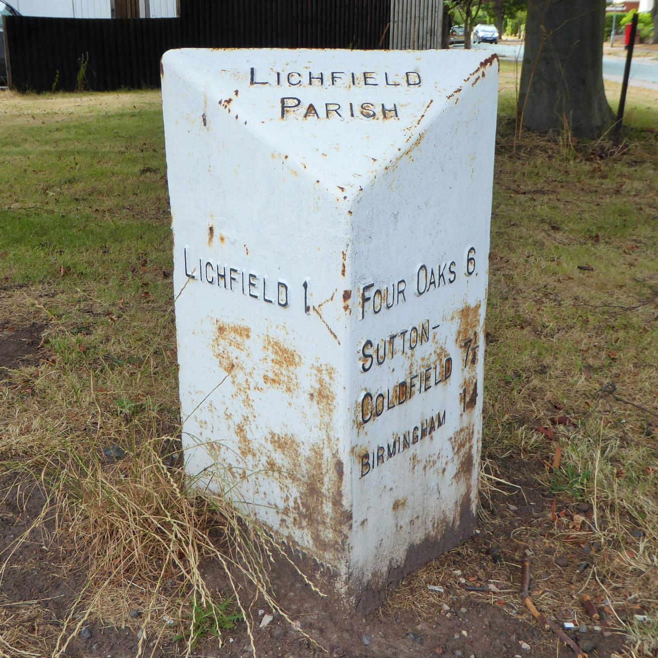
The milepost in Birmingham Road stands on its west side, just south of the crossroads with Fosseway and Shortbutts Lane. In Lichfield Parish and 1 mile from Lichfield, it also tells us that Four Oaks is 6 miles away, Sutton Coldfield 7¼ miles and Birmingham 14 miles.
However, the 1921 OS map reveals that it had not always stood there, being depicted 100 yards or more further south, near to where the Southern Bypass roundabout now lies. The post was moved slightly when the bypass roundabout was built but was then apparently lost. What is seen today is a replica of the Cochrane & Co. milepost. This was made by James Shenton & Co. in 2007 and installed at the crossroads.
|
Local Mileposts
«« The milepost on Birmingham Road The milepost on Stafford Road »» |
|
Ordnance Survey maps from the 1880s show a mile marker in the same place as in 1921; this was probably a turnpike era stone.
Next, we come to Walsall Road. Alone among the routes to and from Lichfield that have or once had mileposts, those on the road to Walsall do not bear distances calculated in miles from Lichfield. The nearest to the city centre was where Walsall Road now turns to meet the Friary at Bowling Green Island. It read "Walsall 9 | Lichfield ½". It was marked on the 1921 OS map but is not on the next edition which was revised in the late 1930s. Perhaps it was lost when the road was diverted in the late 1920s.
The next in the sequence, "Lichfield 1½ | Walsall 8", is still to be seen on the left-hand side of Walsall Road just beyond the roundabout for Burntwood.
But Walsall has not always called the shots. An earlier set of milestones measured distances from Lichfield; the first from the city centre, "Lichfield 1 | Walsall 8½", being shown on early OS maps near what is now the roundabout at the end of Limburg Avenue.
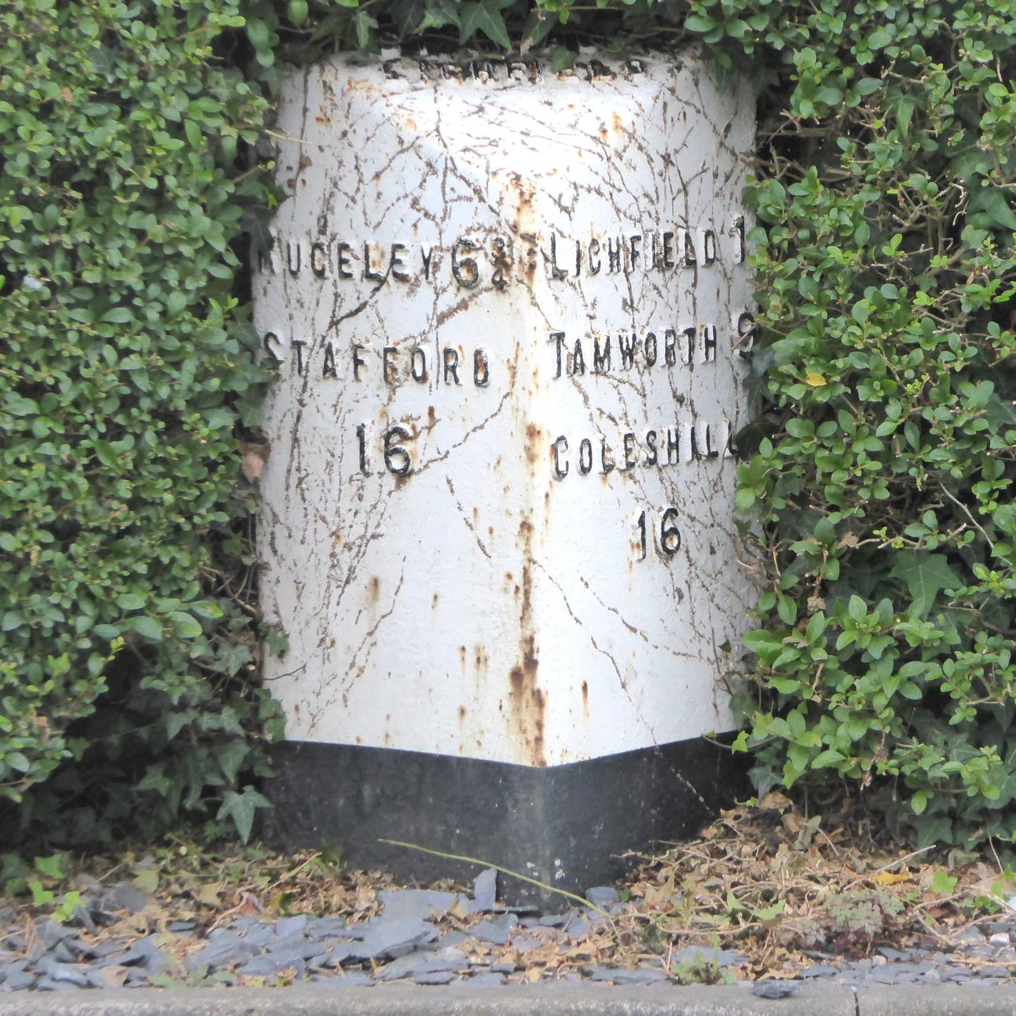
Finally, we arrive at Stafford Road. On the left-hand side heading out of the city, just beyond the Pinfold and somewhat obscured in a hedge, is a milepost stating "Rugeley 6¾, Stafford 16" and "Lichfield 1, Tamworth 9, Coleshill 16". This is one of the mileposts made by Lathe and Co. in the 1890s.
Once again, old OS maps show another, earlier, milestone, which was about a hundred yards further up Stafford Road towards Eastern Avenue. That stone has gone but, if one travels through Brereton on one's way into Rugeley, one can get a fair idea of what it may well have looked like.
On the left-hand side of the dual carriageway approaching the railway arches at the entrance to Rugeley town centre is a rare local survivor of a turnpike era milestone with a cast iron plate. It was "rediscovered" and set in place in 1965 but, as the road had been widened by then, it cannot be in its original position.
|
Local Mileposts
«« The milestone at Brereton The milepost at Longdon »» |
|
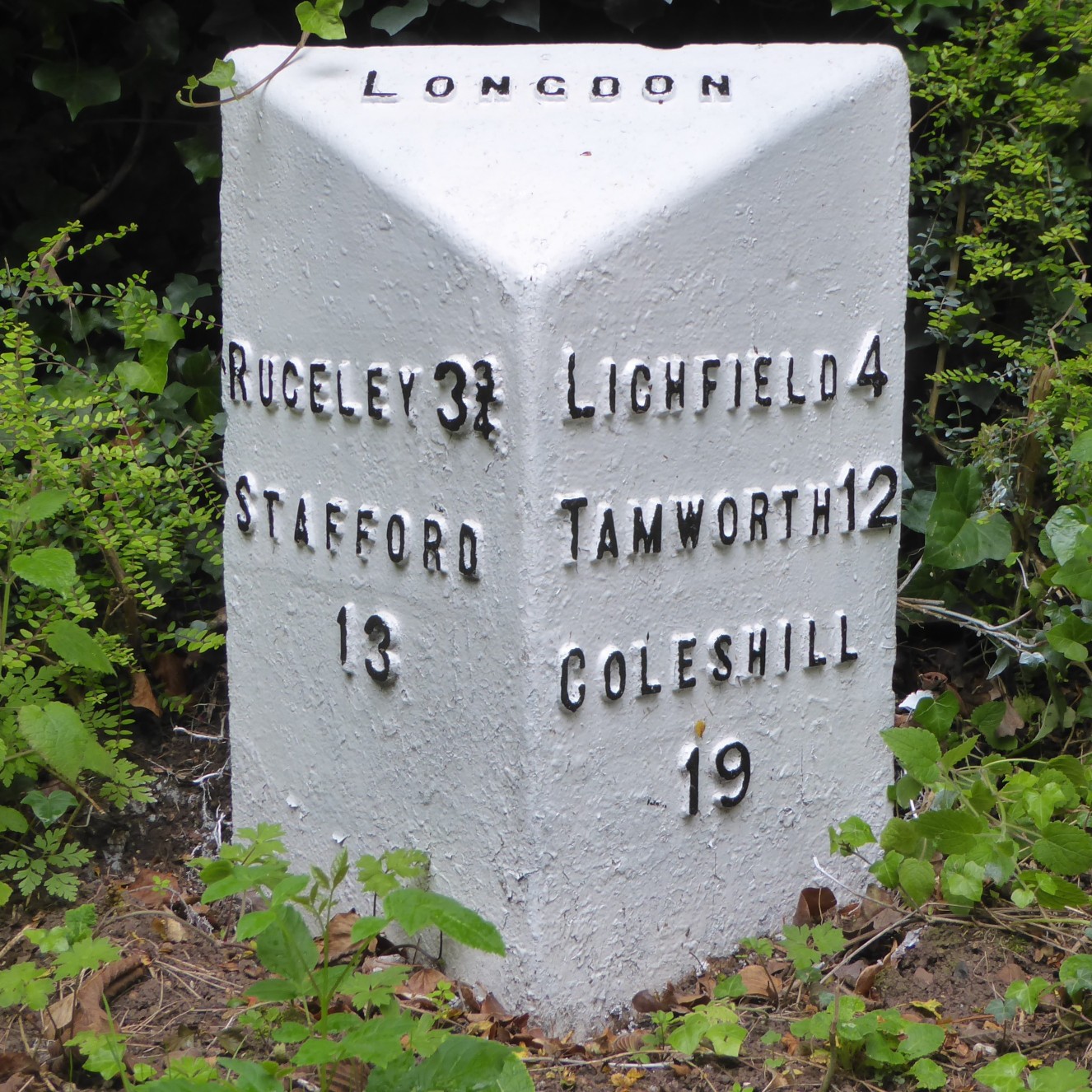
There is another, well maintained, milepost on an abandoned section of the former road to Rugeley in St James' Close in Longdon village. This one reads: "Rugeley 3¼, Stafford 13" and "Lichfield 4, Tamworth 12, Colehill 19". It could be one of the batch made by Charles Lathe and Co.
The road through Lichfield and Rugeley was at one time a section of the Canwell (Bassetts Pole) to Woore (Cheshire) Turnpike Trust, so it is tempting to think that the turnpike era milestones in Lichfield on Stafford Road and London Road would have been of a similar appearance.
The milestone at Brereton has been listed grade II by Historic England. None of the mileposts in the City of Lichfield enjoys such protection but examples of Cochrane & Co. posts near to the city are listed: two on Tewnalls Lane (the A515) in Curborough and Elmhurst parish and one on Walsall Road in Hammerwich parish. Perhaps similar survivors in the city deserve the same status.
This review of just a few of our local mile markers reveals quite a complicated story. All have been replaced over the years, sometimes more than once, while others have been moved or removed.
But 85 years ago, more drastic action was taken. In the summer of 1940 anything that could inform possible Nazi invaders of their whereabouts was covered up or removed. Mileposts and milestones were either defaced, buried or taken away for safekeeping. Most were later reinstated but some were mislaid and others put back some way from their original location. Since then there have been further losses due to accidents, vandalism and, sadly, the theft of cast iron posts and plaques from stones.
Lichfield is therefore fortunate that of the six later mileposts once to be found within the city boundary; three, and a replica of a fourth, are still to be found today if one knows where to look.
All photographs by the author.
Sources:
John Higgins, Sylloge [*] of Mile Markers in Staffordshire (Staffordshire County Council/The Milestone Society, 2008).
Robert Sherlock, Industrial Archaeology of Staffordshire (David & Charles, 1976).
Map extracts from Ordnance Survey 1:10,560 Staffordshire, sheets LII.SW, LII.SE, LVIII.NW, LVIII.NE (revision of 1921).
[*] A sylloge is a collection or summary of documents, data or objects. The word comes from Ancient Greek where it means "collection".
William Henwood
January 2025